
Whychus Creek trails south of Sisters
Last updated 7/7/2009 at Noon
Craig Eisenbeis
Whychus Creek is a scenic wonder right in Sisters’ back yard.
You may notice that the title to my column this week refers to trails - plural. Sadly, this is a reflection of the fact that, close to town, there is no established trail to explore Whychus Creek upstream of Sisters. In some places there is no trail at all; and, in others, there are a multitude of footpaths that spread out and then fade away.
None of this, however, should discourage you from exploring an interesting creek system that is uniquely a part of Sisters. You probably know that Whychus Creek is severely stressed and in need of rehabilitation. One of the best ways to learn about the creek is to go see it for yourself.
If you do, the trails you will find are not the put-your-head-down-and-hike kind of trail. Instead, expect to pick your way along and beat some brush. Long pants are recommended. Still, the terrain is not particularly difficult, nor are you likely to become lost, since the road is always only a short distance to the east.
To understand about the shortage of water flowing in today's Whychus Creek, a good place to start this hike is a little over 2.5 miles south of town on the Three Creek Lake Road. When you see a yellow sign warning of curves ahead and a 35 mph advisory, you're almost there. A guardrail marks the passage of the road over the Three Sisters Irrigation District main canal. Immediately after the canal, turn right onto a dirt forest road and park at a turnaround.
Walk up the canal a short distance to the main canal diversion. There are several irrigation diversions on this stretch of the creek; but this is, by far, the largest. Irrigation water rights from the creek are well established and date back more than a century. You may be surprised to see more water heading into the canal than downstream.
You may also be surprised to note that Douglas fir is common along the creek, and wildflowers are abundant. As you head upstream, the trail - such as it is - crosses a gravel road leading to a private bridge; continue due south. For the next two miles or so, the trails fade in and out. There are smaller irrigation canals to cross, or you can divert east and cross on the road.
As you continue upstream, there will also be spots where the canyon closes in, and it occasionally becomes necessary to find a route farther inland. In addition to the irrigation diversions (some no longer in use) along this stretch, other points of interest include cable remnants from an old cable-chair crossing and a gauging station - which, at first glance, looks like a green outhouse.
The upper portions of Whychus Creek are a congressionally designated Wild and Scenic River. While you've already seen some great scenery, this is where it will start to become a little bit wilder. From this point on, the trails become a little easier to follow, and there is less brush beating. If you don't want to pick your way back along the same route, you can leave a car near here.
A good drop-off point for a second car can be reached by continuing south on the Three Creek Lake Road past Milepost 4. Turn off onto a rough dirt road immediately after a sno-park sign that also denotes Forest Road 16. If you pass a white sign that says "commercial use prohibited without permit," or if you start up a hill, you've gone too far.
The dirt road parallels the main road for a short distance before it turns and forks; take Forest Road 390 to its end at a loop turnaround. The most scenic points on this hike are in the next half-mile; so, if you want a fun, easy upstream hike of a mile or less, you can also start here. Follow the blockaded road until it peters out and point yourself toward the creek.
A very interesting shallow cave is located just beyond the end of that old road. As you head toward the creek, look for an old broken-top Douglas fir. This old, living snag guards the mouth of the cave. Unfortunately, vandals have spray-painted portions of the interior. The cave has obviously seen service as a mecca for immature beer-drinking teens. Hopefully, the closure of the nearby road will be a step toward restoration of the area.
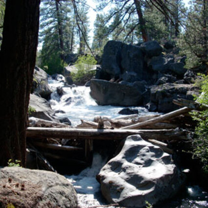
Just a short distance upstream is a very picturesque waterfall and logjam. This is the perfect conclusion for a hike and a great spot for a lunch break. It is possible to continue even father upstream; but, here again, the trails fade away and brush beating through heavy manzanita is necessary.
So, whether you want the longer and more challenging creek hike for a deeper understanding of this important Sisters icon, or just an idyllic stroll with the kids, Whychus Creek will not disappoint you.
This scenic waterfall and logjam can be seen on Whychus Creek, less than five miles south of Sisters.


Reader Comments(0)