
Feds protecting Balancing Rocks
Last updated 6/27/2006 at Noon
Jim Fisher
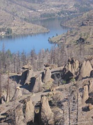
Balancing Rocks are located on a steep slope above the Metolius arm of Lake Billy Chinook.
Visitors to Balancing Rocks near Lake Billy Chinook will now have to walk a bit to visit this unique geological site.
Work to protect the Balancing Rocks area is scheduled to begin late this month, according to Project Manager Michael Keown of the Sisters Ranger District. Last month Sisters District Ranger Bill Anthony invited public comment on an environmental review.
“We had three responses from the public,” Keown said. “Two supported the project with no new issues identified and one suggested that the Forest Service provide access to the site for disabled persons under the American Disabilities Act (ADA). Since we had no ADA recreational facilities on the district of this nature, we elected to make this our first one. The trail to the viewing site will meet ADA standards.”
The project will provide only non-motorized access to the Balancing Rocks area to protect this unique geological resource. Interpretive signage also will be installed, Keown added.
Balancing Rocks is an area of unusual rock formations located near the Metolius arm of Lake Billy Chinook in the most northern part of the Sisters Ranger District. The area is just north of County Road 64 and a mile and a half east of Perry South Campground. Here a number of large, flat, tilted capstones rest on slender pillars of volcanic turf. Some pillars are 20 feet tall or higher with the rock slabs all tilting to the west. Geologists estimate it took hundreds of thousands of years for these formations to build.
The first written record of their existence came from the Pacific Railroad Survey through this area in 1855 while they were exploring for a potential railroad route from the Columbia River south to the Sacramento Valley in California. Dr. John S. Newberry, a physician with the survey, wrote about the group of perched rocks that he viewed on the slope overlooking the Metolius River:
“The fragments of this material which here underlie these large masses of enclosed trap (basalt) were protected from erosion which wore away the surrounding rock, and they were left perched on pinnacles 20 to 30 feet in height, and having a less diameter at the summit than the rock which they sustain.”
While Dr. Newberry drew sketches of many of the spectacular sights he saw traveling through the Oregon Country, for some reason his official report had no sketches of the unique balancing rocks.
Over the years, others found Central Oregon’s balancing rocks and several guide books published articles about them. The rocks have been featured on Oregon Public Broadcasting Television and in at least one motion picture.
Access to the balancing rocks has been by a short spur road that allowed vehicles to drive to an informal parking area and viewpoint overlooking the area.
In recent years, the area has had a moderate number of visitors. However, visitors have left litter and created additional roads, contributing to the erosion of fragile soils in the area. The 2002 Eyerly Fire burned through the area, destroying much of the vegetation.
As restoration work began on the fire area, the Forest Service closed the primitive access, but motorized vehicles since have breached this closure.


Reader Comments(0)