
Experience the 'wild' at the edge of town
Last updated 6/12/2012 at Noon
Craig Eisenbeis
A new trail follows Whychus Creek three miles upstream from a new trailhead south of town.
There's a new trail in town! Close to town, anyway. Although I still catch myself calling it Squaw Creek, a name change doesn't alter the fact that I've been wandering this stretch of Whychus Creek for the last half-century. As a result, I was unprepared for the pleasant and surprising new trail that awaited me just four miles south of town.
The three-mile trail covers some very familiar ground but opens up plenty of new country, as well. The first mile explores some of my favorite old fishing spots from the days before fly fishing lobbyists made Central Oregon streams their private preserve. The second mile carves a pleasant path through a previously tick-infested jungle of manzanita that I frequently hunted in years gone by.
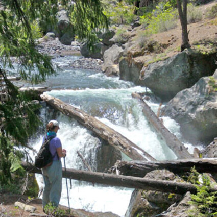
The real treat, for me at least, is the third mile, which I've historically passed by on my way to more distant adventures. Beyond the lava flow that created Peterson Ridge lies a wild, tumbling creek deserving of its "Wild and Scenic" designation.
Although outside the official boundary of the Three Sisters Wilderness, this stretch offers all the beauty and grandeur of wilderness; but, it's still close to town and - for the most part - is pretty close to being an all-season trail.
After the water-level first mile of the trail climbs up to and transits the manzanita plateau of the second mile, the trail tackles the basalt flow that separates the next reach from the closer-to-town stretch that most of us are more familiar with.
This recently completed trail segment has been intentionally left somewhat rough to limit access to foot traffic only, thereby helping to minimize human impact to the area. As a result of this section, a relatively easy hike is probably upgraded to a lower-level "moderate" rating.
Whychus Creek is largely the product of seasonal snowmelt, so the flow varies wildly from time to time; and that aspect of the stream is quite apparent on this segment of the trail. Many streamside rocks are beautifully sculpted by the rock-and-silt-laden high water flows that occur with regularity.
Multiple falls and rapids roar through narrowly carved cuts in the rock, or pass beneath log and debris jams that bear witness to the force and volume of more dramatic seasonal streamflows.
As the trail continues south, it passes ground zero of the 2010 Rooster Rock Fire, which is believed to have been human-caused. It is hoped that future access control will help reduce the likelihood of such incidents.
We saw quite a few wildflowers. Arrowleaf balsamroot and penstemons were much in evidence. I'm not extremely knowledgeable of flowers, but my hiking companion was kind enough to point out some that were new to me. One was the spotted mountain bell, and another the dark woods violet. I had assumed that all violets were, well, violet; but these are yellow. Silly me. I was also schooled in the difference between Solomon seal and false Solomon seal.
When we completed the last stretch of trail, some of which is entirely new, we explored two dispersed camping sites that are temporarily closed for rehabilitation. They will be reopened for public use in 2014. These sites can also be reached by a quarter-mile trail from the end of Road 880.
This access point also creates the possibility of a car drop for a shuttle return, if a three-mile hike is all you are looking for. We were in it for the long haul, though, so we turned around and headed back for our starting point.
The trail offers dozens of great stopping places along the stream for lunch or contemplation. There are perches where long stretches of the creek can be seen tumbling down from the mountains. From a few spots, the mountains themselves are visible; and there are many, many views of falls, rapids, and pools.
We chose to linger at a streamside rock shelf and dangled our feet in the cold water. Even on a hot day, there is relief in the shade and cool water. I think my friend was ready to jump in for a swim but decided the water was still a little too chilly this early in the season.
The return hike was a different view of the same country, but we saw new sights every step of the way for a total hike of about six miles. It's great to have such a nice hike so close to town. This trail is designated for foot traffic only: no horses or bikes.
To reach the northern trailhead, turn south off Highway 20 (Cascade Avenue) onto Elm Street, which becomes Three Creek Lake Road (also Forest Road 16) and continue south for 4.2 miles to a small gravel parking lot on the right. The trailhead is just behind a locked gate.
To reach the southern trailhead for a car shuttle and a three-mile hike, stay on Road 16 for a total of 7.3 miles and turn right at the Whychus Creek sign onto Road 1514 (good gravel), then 1.8 miles and right onto Road 880 (dirt) for two miles.


Reader Comments(0)