
Explore the Metolius above Camp Sherman
Last updated 8/10/2010 at Noon
Craig Eisenbeis
The headwaters of the Metolius River can be reached by vehicle, but a two-mile hike from the Camp Sherman Bridge is a different – and rewarding – way to visit this unique Central Oregon feature.
Every now and then, I'm asked to recommend a hike for people who aren't hikers. Maybe the in-laws are visiting from Florida, or maybe it's your old high school friend whose idea of a hike is when you're stuck with a distant parking space at the shopping mall.
In any event, there are places where you can share the Central Oregon outdoor experience without making your guests feel like they're on a Himalayan expedition. Two of my favorites are the trail to the Head of Jack Creek and the trail to Little Three Creek Lake. However, there is an even more urban selection that is so obvious it's easy to overlook.
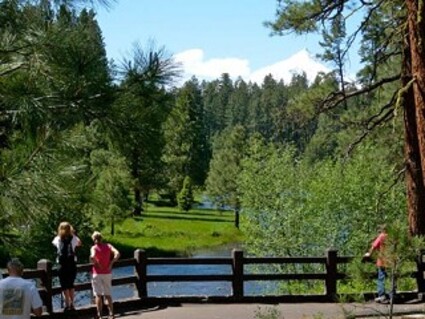
Most of us have visited the Headwaters of the Metolius River at the end of a quarter-mile paved walkway from a restroom-equipped parking lot, but you can also hike there from Camp Sherman. It's only about two miles, which is the equivalent of walking 30 to 40 blocks in a big city. Twice that if you do a round trip instead of a car shuttle.
The trick, of course, is to convince your guest that it's no farther than hoofing it across town for a shoe sale. Once you're actually on the trail, however, the "hike" - and maybe you shouldn't use that word - sells itself. It becomes a pleasant stroll along a beautiful river with beautiful trees and the beauty of nature.
Start at the Camp Sherman Bridge, and check out the fish information signs at the observation platform. As you start to wander upstream along the east bank, your guests will scarcely notice the passage of time as you progress from one feature to the next.
On the opposite (west) side of the river, you will pass the mouths of Spring Creek and soon, Lake Creek. Lake Creek has its beginnings in Suttle Lake, which is now part of a project to restore sockeye salmon runs to the Metolius River system.
By working your way upstream, one earns a growing appreciation of the river as you approach its headwaters. There are birds aplenty, and maybe you will catch sight of a deer, or like I did in this area, a river otter. Also watch for white stones on the river bottom. These markers denote the location of redds, the concave "nests" in the gravel where fish deposit their eggs when spawning.
The hiker is seldom out of sight of Forest Service Road 800, which can be reassuring to those reluctant to venture into the wilderness. At about the halfway point, a bridge crosses the river to an enclave of private cabins leased from the Forest Service.
If you wish to explore the other side of the river, this is your only chance to do so in this stretch of the river; but the way is blocked by a private fence another half mile upstream. Generally, it's better to continue on the east bank for that half mile, where the footpath merges with the Metolius-Windigo Trail for a short detour around the private land.
Just prior to reaching the private land, the trail passes through the Riverside Campground, a Forest Service tent-only walk-in site. This campground is the site of the historic Civilian Conservation Corps (CCC) camp that was established here in June of 1933.
From this site, young men from the CCC built the trails along the Metolius that we still use today. They also built three campground picnic shelters along the river, several fire lookout towers, and roads. Known as "Tree Troopers" or "Soil Soldiers," they also fought fires and planted thousands of trees. An estimated 2,000 men put in time at this camp.
Today, their camp is long gone, and little remains to attest to their presence. Interpretive signage can be found at three downstream campgrounds to tell some of the CCC history of the area.
At the end of Riverside Campground, the trail leaves the river and turns east under the power lines to skirt the private land. Stay west of (paved) Road 14, and follow the trail south to the parking lot at the headwaters. A short jaunt down the paved walkway will bring you to the viewpoint above the headwaters. Having walked upstream from Camp Sherman, the hiker gets to know the river; and it's a real pleasure to see its birth as it flows fully formed from the hillside.
What even most locals don't know, however, is that this is only half of the headwaters. About 200 yards due west is another almost identical spring. The two streams flow together within a short distance, and their combined flow is a constant 45,000 to 50,000 gallons per minute.
By the time the river reaches Lake Billy Chinook, 30 miles away, it swells to more than ten times that volume. With only a few exceptions, the river's tributary streams enter from the west, feeding off the snows from the eastern slopes of the Cascades .
Even at a leisurely pace, this hike doesn't take much more than an hour in each direction. Perhaps, after accomplishing this feat, your guests will decide that they are ready to try a "real"
hike.
To reach Camp Sherman, head west from Sisters on Highway 20 for about 9 miles and turn right (north) and follow the signs. To reach the headwaters site by vehicle, take the right fork off the Camp Sherman Road at about 2.7 miles; the headwaters parking area is about a mile and a half on the
left.


Reader Comments(0)