
Hiking Green Ridge
Last updated 6/22/2010 at Noon
Craig Eisenbeis
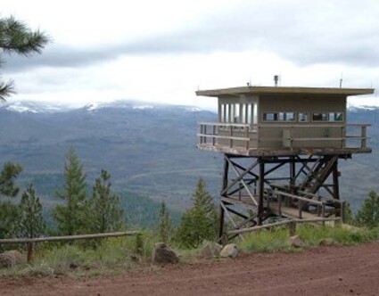
The Green Ridge Forest Service Lookout, at the north end of a 10-mile hike along the crest of Green Ridge has spectacular views of the Cascades and can be rented by the public for overnight stays.
Perhaps three to five million years ago, the rocks of Green Ridge were laid down. More recently (1.5 million years ago), the Cascade mountains formed. Ensuing pressure along north-south fault lines eventually lifted the older rocks of Green Ridge to form the magnificent miles-long hillside that cradles the Metolius River against the Cascade slopes. When Black Butte rose up, a mere half-million years ago, it plugged the south end of that trough, thereby ensuring that the Metolius River would ever after flow north.
Today, the Forest Service has a trail that allows us latecomers in geologic time to explore all this, pretty much from one end of the ridge to the other. The poorly marked trailhead takes off from the 1120 road north of Black Butte, before the road drops down toward Camp Sherman. It's about 10 miles from the trailhead to the Forest Service lookout that clings to the northern edge of the ridge.
Marked by yellow plastic diamonds on the trees, the Forest Service has designated the Green Ridge Trail as a horse trail. We traveled it on foot, however, and I've talked to others who have mountain-biked it. The southern part of this hike has five miles of excellent trail. The northern half becomes kind of a mess, especially in and around the area burned by the Wizard Fire.
The ridge itself rises more than 2,000 feet above the river, but the location of the trailhead cuts that elevation gain in half. This hike begins at about 3,700 feet and tops out at around 4,800. Of course, the trail can be hiked in the downhill direction, but where's the fun in that?
To begin this hike, we took two vehicles to the lookout, dropped one there and drove back to the trailhead on 1120. This is a rather tedious procedure that takes nearly an hour, but it's still easier than hiking a roundtrip of 20 miles.
This northbound trek starts out heading east toward the ridge, then takes a sharp turn south before a giant switchback points the trail due north, a direction from which it seldom deviates. Most of the elevation gain occurs in the first three miles in a beautiful old forest of orange-barked ponderosa pines.
This portion of the trail is very distinct and is profusely marked with yellow diamonds in both directions. At about the two-mile point, sweeping vistas of the Cascades and the Metolius Basin open up and are your constant companion for the next three miles or so.
Much of the ridge top is a beautiful open forest with meadows, wildflowers, Douglas firs and true firs. Sugar pines, with their gigantic cones, are uncommon in Central Oregon, but I've seen a few on Green Ridge.
Just north of the ridge's midpoint, we spotted some unusual birds, which I was able to later identify with the help of local naturalist Jim Anderson. They were merlins, or pigeon hawks - a small forest falcon - and the confusion was caused by their exceptionally dark, mostly black plumage. Peterson's guide notes a "dark race," the black pigeon hawk, more common in British Columbia.
We also observed a large quantity of unusual carnivore scat heavily loaded with animal hair. We speculated as to whether the depositor was bear or cougar; but, the next day, I spoke with a local resident who added to the possibilities by reporting that he had spotted a wolf in the area. ODFW confirmed that they have received several reports of a wolf or wolflike animal in the area and would welcome reports and photos of any additional sightings.
At about six miles, the trail drops slightly to the east side of the ridge and the forest thickens on the western slope. At this point, the trail skirts the eastern edge of a knob on the ridge and enters a wide open swath in which reforestation has inexplicably failed.
From this point on, the "trail" becomes largely two-track and lapses onto roads which are still in use. The purveyor of yellow diamonds also became very stingy with the markers in this middle stretch. The prevalence of roads and lack of markers leaves the hiker with a feeling of uncertainty about the trail. Generally, the hiker is advised to take roads that bear to the left (west), since the steep western slope becomes a limiting boundary.
One exception to the "left" rule is a very rough fire road at the southern edge of the Wizard Fire area. This road leads down and nowhere and is obviously not part of the intended trail system. Once into the burned zone, there are more deadfalls and detours and a continuing shortage of yellow diamonds.
The northern portion of the trail also has some spots of tall, dense manzanita and snowbrush that close in on the trail. On my way home, I stopped at Ray's, and a friend spotted a tick crawling along my shoulder. I probably picked it up in this area.
The Wizard Fire left an ugly scar on this part of the ridge and came very close to destroying the lookout, which lies about 0.3 mile behind a gate that is kept locked for much of the year. The lookout is manned on a part-time basis, but the Forest Service rents it to the public from April 15 to June 30 and from September 15 to November 15. Renters and lookout personnel are not obligated to host those who visit the site.
The lookout has sweeping views of the Metolius Basin, Three Fingered Jack, Mt. Jefferson, the southern part of the Warm Springs Indian Reservation and other regional points of interest.
To take advantage of this trail opportunity, take Highway 20 west of Sisters to the Green Ridge and Indian Ford turnoff (about 5.5 miles). Take Forest Road 11 4.3 miles to a sharp right turn, where the 1120 road takes off to the left. The southern trailhead is on the right (north) 0.8 mile down that red cinder road.
To reach the lookout by road for a vehicle shuttle, continue on Road 11 past the 1120 turnoff for another 5+ miles to where the pavement ends. Follow the sign to the Green Ridge Lookout and bear left on road 1150 for about 6 miles. There, another sign points left to the lookout on road 1154. There will be another sign and left turn onto road 1140 after about a half mile. A couple of hundred yards later, the last turnoff is to the right (and unmarked) onto Road 600. The green metal gate to the lookout is about 0.75 mile on your right.


Reader Comments(0)