
Walking in Cow Pies?
Last updated 11/5/2019 at Noon
Kathleen Eisenbeis
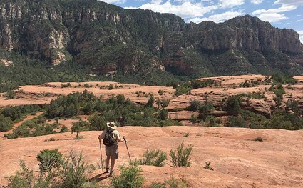
These layered red rock formations are said to resemble enormous cow pasture deposits on the Cow Pies Trail near Sedona, Arizona.
Since we’re in that “shoulder season” for hiking in our area, when the white “termination dust” is calling an end to mountain access and friendly hiking weather, the typical hiker is thinking about hiking alternatives. For more than a few residents of Sisters Country, those “alternatives” often include forays to warmer and sunnier destinations to the south.
One of the most popular such destinations is Arizona; and, for many locals, Sedona is the go-to goal for off-season hiking. As a result, each year about this time, I like to feature a Sedona hike.
Years ago, on one of our very first trips to Sedona, we randomly selected a hike off Schnebly Hill Road, which is quite close to the downtown area. As it happened, the trail we chose was the Cow Pies Trail, which is so named for several outsized red rock formations that are said to resemble the semi-liquid, layered “deposits” common to... cow pastures.
Back in the day, when we first visited the Cow Pies, Schnebly Hill Road was an unremarkable gravel-and-dirt road, typical of access roads leading to out-of-the-way trailheads. Fast forward to today, however, and Schnebly Hill Road has deteriorated to become one of the worst roads known to humankind; and the Forest Service seems quite content to leave it that way. Do not even think about attempting to drive this road without a high-clearance four-wheel-drive vehicle. Hardly a year goes by without someone disregarding the warnings and ultimately leaving engine oil and scrap metal littering the road.
If you do not have the requisite vehicle, however, despair not because the Munds Wagon Trail parallels this awful road and makes a very short and easy hike of about three miles into a more challenging eight-or-so-mile roundtrip from the end of the paved road.
The scenic red rocks of Sedona are legendary, to the point where the list of movies, television shows, and advertisements shot among these unique rock formations is a long one. Although dramatic scenery is impossible to avoid in this area, the Cow Pies Trail features some of the very best.
The Cow Pies, themselves, although extraordinary in scale, definitely do resemble their namesakes, as if deposited by a gargantuan celestial bovine in eons past. Upon reaching the Cow Pies, there is no exact carved trail over and among them, but they can be easily explored and clambered over. From the trailhead on the terrible road, this a very easy hike, with very little elevation gain or loss — unless you choose to go all the way to the top of the ridge off the Hangover Trail.
The Hangover Trail, which continues beyond the Cow Pies, adds another five-plus miles onto this hike. With a sort of double meaning, the Hangover Trail features rocks that hang over the trail, while the trail also reaches out, itself, and hangs over precipitous drop offs. It has been labeled as one of the seven scariest bike trails. A side trip onto a saddle, on the ridge to the north, ends at a spectacular viewpoint atop a dizzying precipice overlooking Sedona proper and Oak Creek Canyon, more than a thousand feet below. It’s a great spot to stop and have lunch or just sit and contemplate... whatever.
There is not much trailside vegetation, but there is enough to provide occasional shade; although the mild temperatures at this time of the year make for pleasant hiking – even at midday. Regardless, always be sure to bring plenty of water because this is dry country.
The Cow Pies Trail is very close to town and easy to find. Heading south from downtown Sedona on Highway 179, it is just across the Oak Creek Bridge on the way out of town. Take the roundabout three quarters of the way around and follow the sign to Schnebly Hill Road. It is about a mile to the end of the pavement and, if you dare, another 2.7 miles of astoundingly terrible road to the trailhead. There is a sizable parking area on the right side of the road, which is on the opposite side of the road from the trail, which takes off to the north.
Schnebly Hill Road is named for Carl Schnebly who settled in the area in 1900. He was the area’s first postmaster; and he named the postal station after his wife – Sedona, whose name now graces the town that subsequently sprung up in the early twentieth century.
Some of the permit requirements for parking and use of many of the red rock areas in Sedona have been relaxed in recent years, and federal park and forest permits are now valid for most federal areas. Daily permits are also available. State park areas, however, may require separate permits.


Reader Comments(0)