
Adventure in the Mt. Jefferson Wilderness
Last updated 9/1/2009 at Noon
Craig Eisenbeis
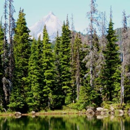
Mt. Jefferson rises above Cabot Lake, northwest of Camp Sherman.
The hike to Cabot Lake is a nice little jaunt of less than four miles round trip. The most rewarding option on this trail, however, is to hike all the way to Carl Lake. Add in a little lakeside exploration, and you've got yourself a very respectable 10-miler!
All of this hike is tucked away in the heart of the Mt. Jefferson Wilderness Area. Carl Lake itself sits upon the shoulders of the mountain. Hikers enter the wilderness only a couple hundred yards from the trailhead parking area. A free wilderness permit is required.
The first mile-and-a-half are inside the boundaries of 2003's B&B burn, but the amount of forest regeneration here is astounding. Young lodgepole pines are sprouting everywhere. It won't be long before these trees form dense fire-prone thickets of their own. New ponderosa pines are also in evidence, as are a few white pines and other small conifers. Wildflowers are past their prime; but last week a few, such as fireweed, were hanging in there.
One plant that is doing a little too well for hiking purposes is the snowbrush. These fragrant, evergreen shrubs are growing so successfully that the trail is obscured in places. In fact, you can be standing in the middle of the well-worn trail and not be able to see your feet! Snowbrush leaves are succulent and not particularly scratchy; but, if you don't like having your skin constantly brushed, you might consider zip-off trouser legs on a hot day.
Leaving the burn area is like passing through a magic curtain, and the change is immediate. Along with mature living trees and a new array of forest vegetation are a multitude of huckleberry bushes. The berries are well past their peak now; but, if you hurry, you may still find a few of the tasty treats in shady areas farther up the trail.
Cabot Lake lies just short of the two-mile point and is not marked. In fact, we failed to even notice it on our way out; so, keep alert for a trail leading off to the right. The picturesque little lake is a short distance down a steep slope. This is a good place for a break after about an hour on the trail. Last week, we saw hordes of colorful butterflies, and an orange-bellied waterdog (salamander) prowling the shallows.
After leaving Cabot Lake, the trail begins a serious climb, although the switchbacks are so sweeping that the climb is not at all strenuous. The total elevation gain on this hike is about 1,000 feet. When the trail starts to flatten out along a ridge, it turns due west.
Eventually, the trail swings north and passes a series of ponds, some of which practically beg for swimmers on a hot day. The portion between the switchbacks and the ponds seemed like the longest stretch. Purple asters are the most prominent wildflowers still blooming in this area.
After the last pond, the trail trends uphill again; then, suddenly, you're there. Carl Lake is beautifully perched between the mountain and the valley below. North of where the trail reaches the lake is a relatively narrow wall of rock that seems to keep the lake propped in place. Further inspection of this spot shows that, at times of spring runoff, a cascade of water flows from the lake into the valley below. This time of year, however, the waterfall is dry.
We ate lunch in the shade of hemlock and noble firs at the edge of the lake. Noble fir is easily distinguishable by its potato-sized cones. Whitebark pine is also found at the lake.
Leaping trout kept us entertained with their aerial acrobatics. Mostly in the 8- to 12-inch range, the fish took turns in jumping feats of various degrees of difficulty ranging from full cartwheels to belly flops.
If time allows, there is much to be explored in this area. The lake itself offers an interesting geologic study, including evidence of bedrock gouged by long-gone glaciers. Of note, at this point, the Warm Springs Indian Reservation is only about four miles to the north.
For additional side trips, a trail leaves the south shore for Shirley Lake, then continues up to the Pacific Crest Trail. From there you can turn south for a quarter mile and scramble up South Cinder Peak, a red cinder cone. The summit is about two miles from Carl Lake.
South Cinder Peak rises to an elevation of 6,746 feet and offers a bird's eye view of Mt. Jefferson, as well as superb views of the Three Sisters and other peaks. Of course, if you want to explore all the possibilities at Carl Lake, you might plan to spend a night - or two.
To reach the Cabot and Carl Lakes Trailhead, take Highway 20 west from Sisters for 12 miles and turn right onto Jack Lake Road (Forest Road 12). Continue about four miles to where the road curves to the right; take the Jack Creek turnoff to the left (Road 1230).
In about two miles, the pavement ends and the road splits. Take the right fork and stay on road 1230 to its end, a total of about 12 miles from Highway 20. Signs point the way to the Cabot Lake Trailhead. There is no fee station.


Reader Comments(0)