
Scout Camp Trail leads from CRR to the mouth of Whychus Creek
Last updated 5/18/2010 at Noon
Craig Eisenbeis
Whychus Creek, on the right, merges with the Deschutes River as seen from this viewpoint on the Scout Camp Trail near Crooked River Ranch.
The newly completed Scout Camp Trail takes off from Crooked River Ranch and is VERY difficult. If you don't like steep terrain, cliff edges, and heights, you would be well advised to stay away from this one. There is even a spot where it is necessary to climb a vertical rock wall about eight feet high.
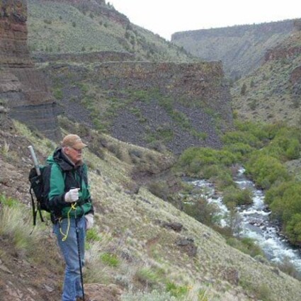
That said, this short three-mile hike offers some of the best river canyon scenery in Central Oregon. Naturally, we tend to associate Crooked River Ranch with, well, the Crooked River. What's not so obvious, though, is that part of the ranch also sits on the edge of the Deschutes River Canyon; and this also happens to be where our very own Whychus Creek joins the Deschutes.
Most every hiker I know has taken the Alder Springs Trail to the mouth of Whychus Creek, but this new trail leads to the mouth of Whychus Creek on the east side of the Deschutes River.
After negotiating the street maze that comprises Crooked River Ranch, the hiker reaches a BLM trailhead that takes off from a fine information kiosk with a splendid topographical map of the trail area. The loop trail was completed in just the last few weeks, and no one else was on the trail when we hiked it.
Of course, the lack of hikers may also have been due to the fact that it snowed for much of the time. Fortunately, it was graupel snow (also known as "corn snow"); so it bounced off us rather than getting us wet. Graupel is often mistaken for hail and is still sometimes called "soft hail." Yes, this hike was in May and, yes, it was below 3,000 feet elevation. But what the hail, this is Central Oregon.
A short distance down the trail, we encountered a well-marked trail fork with the foreboding warning of "MOST DIFFICULT" pointing to the left. If you want to do the entire loop, it's probably easier to take the left fork right away and get that part over with. A round trip using only the right fork, however, is an option to avoid some of the most demanding terrain - and the wall climbing.
Descending the trail is treacherous even without snow. Tiny bits of rock and soil acted like little ball bearings on the very steep slope, and we kept a close eye on the precipitous drop-offs to the river below.
This portion of the Middle Deschutes has been designated a "Wild and Scenic River." The staff at the Sisters Ranger Station warned us to watch for rattlesnakes, but the snowy day probably discouraged their activity.
Arrowleaf balsamroot, buckwheat, heather, paintbrush, and plpfs are only some of many flowers that were already in bloom. Not having a botanist along, plpf is what we generically labeled the surprising array of "pretty little purple flowers." The real scenic wonders here, however, are geologic - the spectacular 500-foot canyon walls.
We followed the trail all the way to the river's edge, which was a delight but also a minor navigational error. Fishermen's paths diverge from the main trail to explore the riverbanks, but the actual trail route stays higher and crosses a rocky stretch. While finding our way back to our intended route, we observed dense riverside vegetation, including alder, dogwood, clematis, chokecherry and more.
There are some beautiful, deep river pools in this area, but an avid fisherman in our party insisted that I report that there are "absolutely no fish in this part of the river." If so, I guess the ospreys circling above us were only making training runs.
The main trail parallels the river at the base of the cliffs until it appears to end in the river near a small cave. This is where we had to scale the solid rock wall that blockaded the trail. The climb isn't quite vertical, plus there are plenty of good handholds and an adequate shelf at about the four-foot level. No, it's not like dangling from Smith Rock, but it's enough of an obstacle that timid or less nimble hikers should not attempt this trip.
Sure enough, though, beyond this rock ridge, the trail began again and trended slightly upward as we neared the mouth of Whychus Creek. As the trail rises, the two separate waterways can be seen more distinctly. It is a real treat to look across and see the rock shelf on the opposite side of the Deschutes River that is the usual lunch spot destination for hikers on the Alder Springs Trail.
Due to the snow and chilly temperatures, we didn't linger here as we might have on a warmer day. The trail up this part of the canyon is less precarious but plenty steep. There is a sharp switchback to the right where a side trail continues on downstream. The spot is marked by a big post in the trail; take the switchback to return to your starting point.
By the time we returned to the plateau above, the trail had turned white from the snow. One of our party thought that was enough adventure for the day and suggested a stop for burgers and beer in Redmond. The Seventh Street Brew House proved up to the challenge.
To find this new and interesting hike, enter Crooked River Ranch, north of Terrebonne, by taking 43rd Street off Lower Bridge Road. Follow 43rd for 1.7 mile and turn left onto Chinook Drive. After 2.3 miles, turn left on Mustang for 1.1 mile, then turn right onto Shad Road. Travel 1.4 mile on Shad, and turn right on Peninsula Drive. Take Peninsula for 3.2 miles, and turn left on Meadow Road. After a half mile on Meadow, turn right on Scout Camp Trail. From there it's only a couple hundred yards on a good gravel road to the turnaround loop and trailhead parking area. All of these roads are paved except for this last short section.


Reader Comments(0)