
Wasco Lake is a less-crowded hiking destination
Last updated 7/23/2013 at Noon
Craig Eisenbeis
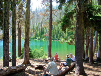
Hikers take a lunch break among unburned trees along the north shore of Wasco Lake.
Wasco Lake came to mind recently because of the current Forest Service initiative under consideration to decommission several miles of trails in that area. If the trail closures are enacted as proposed, Wasco Lake would still be accessible from Jack Lake, but it would not be accessible from Bear Valley to the east.
Since the B&B Fire 10 years ago, the eastern access has not been maintained and is largely impassable amid a tangle of dead trees. So, today's hike to Wasco Lake will focus on the maintained trail from Jack Lake.
Wasco Lake is not a common destination, and most local hikers are familiar with it only by virtue of a trail sign pointing away from the much more popular Canyon Creek Meadows loop trail. In reality, Wasco Lake is a nice little destination in itself.
The trail takes off from the Jack Lake Trailhead, is relatively easy, and is less than a five-mile round trip. Just short of a half-mile in, the trail forks in the vicinity of the Mt. Jefferson Wilderness boundary sign. Instead of following the recommended clockwise loop left to Canyon Creek Meadows, take the counterclockwise direction to the right.
After a total of about a mile-and-a-half of hiking, the trail meets up with Canyon Creek itself near a scenic waterfall. Shortly afterward, the trail forks again; and a weathered sign points the way to Wasco Lake on the right fork. The trail crosses Canyon Creek at a ford that offers multiple crossing options...and opportunities to get wet. From here, it's about three quarters of a mile to Wasco Lake.
Almost all of this hike is within the boundaries of the 2003 B&B burn, but there is also a large unburned stretch on this route that offers shade during the hike. Unfortunately, each year it gets harder and harder to find unburned forest hikes in our area.
Natural reforestation is actively underway; and, as usual, lodgepole pines are leading the charge. In this area, however, the new trees are decidedly more mixed-forest than I've seen in many of the burned-over regions. Many of the new seedlings include a variety of firs. Spruce and white pine are also in evidence.
It comes as no surprise that another plant that is doing very well in the burn area is manzanita. These evergreen shrubs with the reddish-orange bark thrive in burned-over lands and have already grown several feet high in many areas. My hiking partner pointed out that the plant's name derives from the Spanish for "little apples." Sure enough, many of the bushes had green berries that resembled tiny Granny Smith apples.
The trail is usually well-maintained by Forest Service crews or volunteers; but, the burned trees have been dead for 10 years and are falling with increasing regularity. So, don't be surprised if a few obstructions are encountered.
Wilderness permits are required and are free and available at the trailhead, so there is just no reason not to comply. Forest Service officials advise that the maximum penalty for non-compliance is a $200 fine.
It would be nice to add nearby Minto Lake to this hike; but, if that's on your agenda, be prepared to mount a difficult overland expedition. The most recent Forest Service trail bulletin states, "BEWARE! Since 2003... Minto Lake Trails... have been in a 'no current maintenance' condition. With heavy blowdown, dense brush, lack of identifiable trail surface and erosion due to B&B Fire damage, these trails are considered impassable and are not recommended. In recent years several hikers have reported becoming lost trying to follow these trails from the west, with a few turning into search and rescue missions."
"No current maintenance" is kind of an understatement: The Minto Lake Trail is just plain gone.
Wasco Lake itself, however, is a very nice destination and a great place for a refreshing swim. The water is clear, but the irregular rocky bottom is covered with several inches of very soft, loose ooze, so the footing can be a little awkward.
There is a nice grove of scenic survivor trees along the north side of the lake that is the perfect setting for a relaxing stop and lunch. Most of the lakes in the burned forest have a strip of shoreside trees that survived on the lee side of the lake as the flames swept on by.
Another thing to keep in mind is that Wasco Lake is sometimes deserted on days when the Jack Lake parking lot is full of cars whose owners all head for Canyon Creek Meadows. I have to admit, however, when I say something like this, it's not unusual for me to receive complaints that my column sent great hordes of hikers to someone's favorite secluded spot.
To reach the Jack Lake Trailhead, take Highway 20 west from Sisters for 11 miles. Turn right onto Jack Lake Road. Stay on paved Forest Road 12 for 4.3 miles to a right-turning curve, where you make a left turn toward Jack Creek. Cross the one-lane Jack Creek Bridge and continue straight about a mile-and-a-half until the pavement ends. Follow the sign to Jack Lake on gravel road 1234 for about another five miles to where the road ends.


Reader Comments(0)